
Why I Love the SHTA’s Trail Atlas
May 25, 2023
By Chris Pascone, guest blogger
Who else had a ball on the SHT last fall? The sunshine, warmth, and dry weather of fall 2022 was made for hiking. You couldn’t ask for better.
I took each of my middle-school-aged daughters on overnight backpacking trips, as we do every fall. This year we did Lismore Rd. to Martin Rd., and Reeves Rd. to Lake County Demonstration Forest. There was ample father-daughter trail bonding, along with the universal qualities of the SHT: the smells, the views, the wayfinding.
Wait, did he just say wayfinding? It’s true! I love maps! Specifically – paper maps. And I have a new personal favorite: the SHTA’s 1st edition Trail Atlas, published in March 2021.
This nugget of gold-on-paper has quickly become one of my all-time favorite maps. It’s way up there with my paper McKenzie Maps of the BWCA, and my Sportsman’s Connection Northeastern Minnesota All-Outdoors Atlas. The SHT Trail Atlas is tremendously satisfying to use! Here’s why.
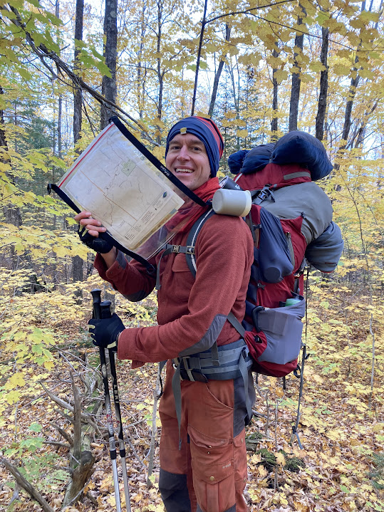
Let’s start with the 8 ½” x 11” loose page format. This system is ingenious for backpackers: take only the pages you need for the route ahead. Leave the rest at home, so they don’t get lost on trail or crushed in your pack. I love the standard size paper too: you don’t have to struggle trying to fold a big map down to a crumpled, irregular square.
The Trail Atlas pages fit perfectly into my medium-sized waterproof SealLine map case. It’s the same one I use for canoe camping! I put my SHT map pages inside, clip it onto my shoulder strap with a carabiner, and then either let it hang on my side if I expect to be referencing the map often, or stuff it between my back and my pack to completely forget about it. No more folding the map, taking it in and out of my pocket, dropping it on the ground, turning it right side up, endlessly.
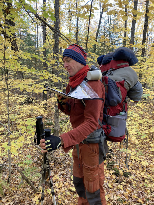
The Trail Atlas in a transparent map case provides easy, dependable access, while also ensuring the maps’ durability. And whether in rain or frost, you won’t get lost.
Secondly, I’m a huge fan of the added detail in the Trail Atlas. I’m particularly pleased that these maps show intersecting trails and roadways. As an avid backcountry skier and bikepacker, I want to know all the tantalizing possibilities out there. The plethora of trail systems that interconnect with the SHTA is mouthwatering! The fact is that the SHTA crosses hundreds of other trails. Don’t you ever wonder where those other trails go as you cross them? The Trail Atlas allows me to plan cool bike-and-hike loops. The SHT quickly becomes a conduit to even more new adventures with the Trail Atlas.
Finally, I get peace of mind taking a paper map that is big, easy to read, and doesn’t require a battery to operate. No matter how many times you look at it, it doesn’t go dead. You can’t break the Trail Atlas, and it’s hard to lose it when it’s strapped to your backpack. It’s going to get you where you want to go no matter what, and that level of confidence is clutch. A $25 investment for the Trail Atlas guarantees you can find your way on the SHT. That’s how much trust I put into these maps. They have yet to let me down.
All people interact with maps differently, but the SHT Trail Atlas serves a well-crafted niche that will put the spirit of adventure, old-fashioned quality, and complete reliability into your hands for your next SHT foray.
About the author
Chris Pascone is a Minnesota outdoorsperson who lives in Duluth with his wife and three daughters. He went to Macalester College in St. Paul, and now teaches in the School District of Superior (WI) and Northwood Technical College. His passions are exploring the outdoors with his family and urban farming. He prioritizes low-tech adventures with paddles, skis, or fishing equipment.
Trail Atlas Updated April 2023
This spring, our Trail Atlas was updated to include new information, including:
- New Gooseberry Route: 4.2 new miles of Trail were built to close the Gooseberry Gap last year. This new route has been added to our printed and digital Trail Atlas.
- Other small trail reroutes. As we continue our Trail Renewal Projects, small trail reroutes will occur to move the tread to more sustainable locations. These slight reroutes have also been included.
- Numbered mile markers.
- Trailhead names.
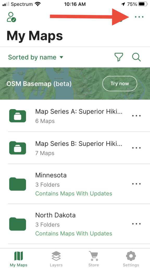
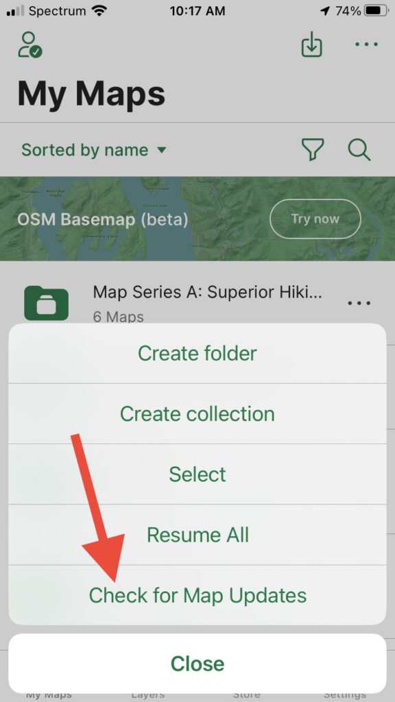
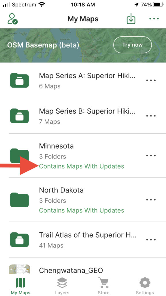
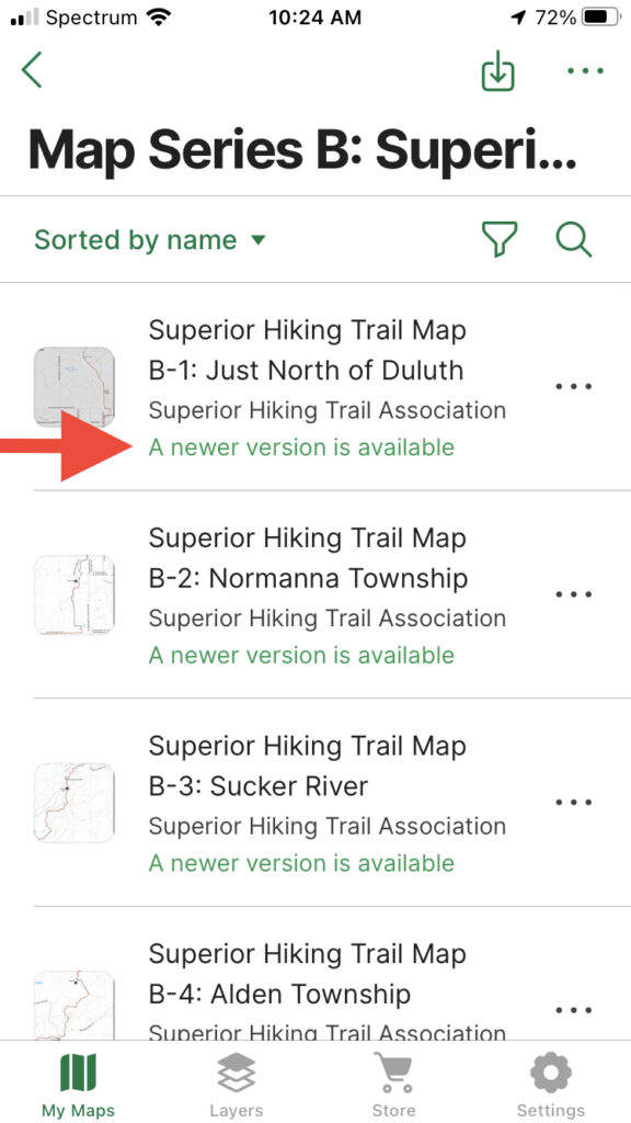
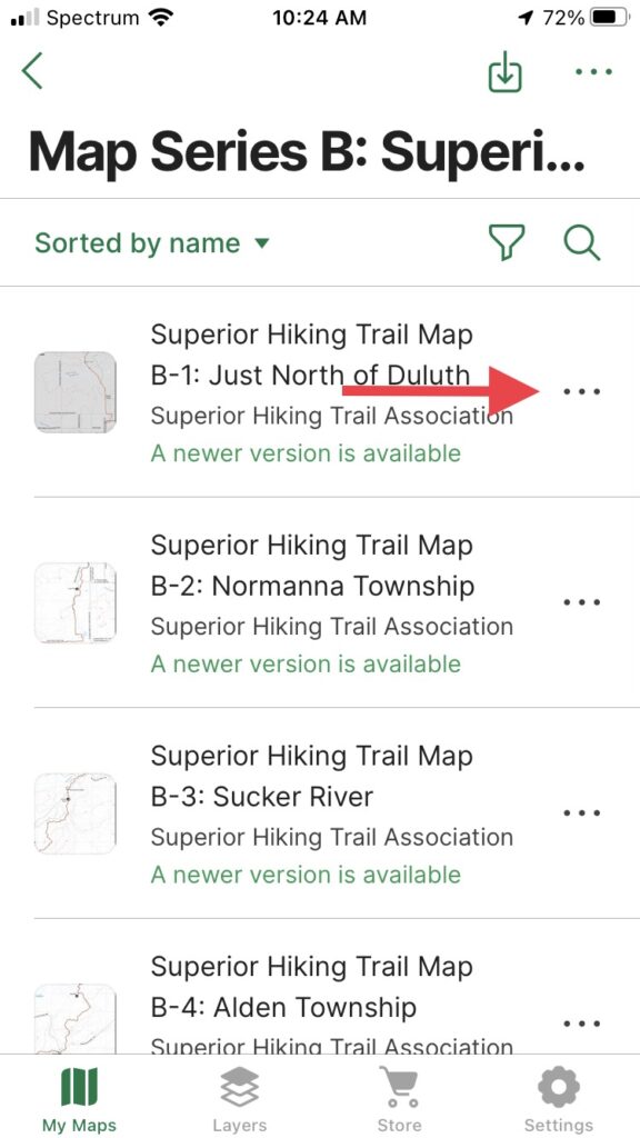
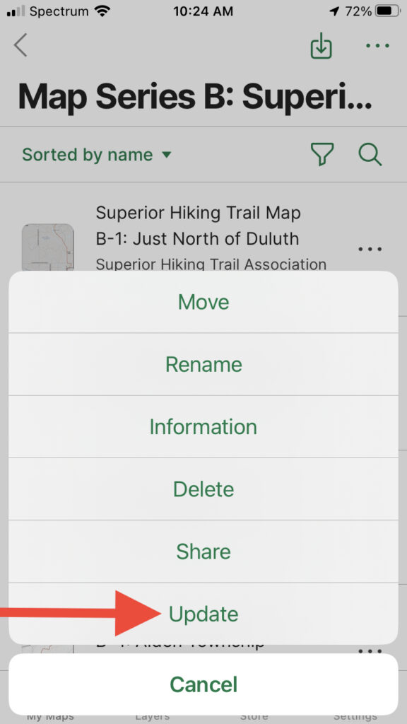
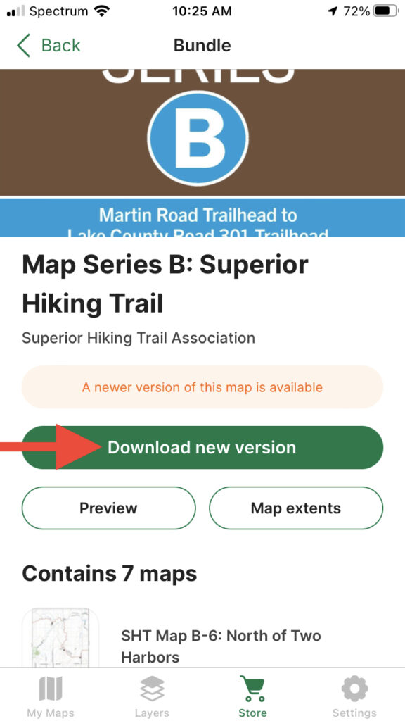
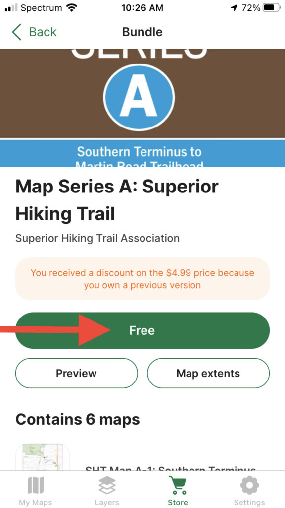
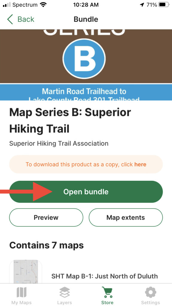
If you own the digital Trail Atlas, any time we update the maps, you get the new version for free. To update your maps, follow these steps (This is how the process appears on an iPhone. Each phone platform has its own version of Avenza, and the exact steps may differ a bit, but the general process should be the same across Avenza’s app platforms):
Latest Blog Posts