Trail Conditions
Fire Ban
Fires are banned along the entire Superior Hiking Trail. Due to dry conditions, wildfire risk, and extremely high temperatures, the Minnesota DNR and U.S. The Forest Service has issued campfire restrictions. Due to high fire danger along the entire Superior Hiking Trail, do not have a campfire at any SHT campsite or use stoves without an off switch. Camp stoves and small backpacking stoves (propane, butane, alcohol) are allowed.
For more information on fire restrictions, visit
• Superior National Forest website https://www.fs.usda.gov/r09/superior/alerts
• National Fire incident reporting system –https://inciweb.wildfire.gov
• Minnesota Incident Command System website at https://mnics.org
Wildfires – Air Quality
The wildfires in Minnesota are creating air quality issues on the Superior Hiking Trail. To check if a wildfire is impacting the air quality along the SHT, visit airnow.gov, where they also provide information on how to assess the air quality risk here. To see an interactive map of active U.S. wildfires, go here. If there is ever a wildfire burning near or on the SHT, we will list it on this page on the relevant Trail section.
Updated July 14, 2026
Trail Conditions by Section
Southern Terminus to Martin Road Trailhead – Map Series A
131st Avenue West to 123rd Avenue West
- The Sargent Creek Bridge has been removed and replaced with a stone step crossing.
Spirit Mountain Grand Avenue Chalet Trailhead to Skyline Parkway Trailhead
- The snowmobile trail bridge has been replaced and the main trail has been routed back across it after flood damage in 2012. The route below the snowmobile trail on both sides of Kingsbury Creek has been blazed white and is now a loop trail to the Waseca Street Trailhead near the Lake Superior Zoo.
Spirit Mountain Loop
- A route change is being made on the 3.5-mile Spirit Mountain Loop route. This is not a reroute. We are switching which side of the loop is the spur, and which is the main trail. The main SHT route will now follow the 1.9-mile trail forming the west side of the loop, or the “top” of the loop. The spur trail will now be the 1.6-mile trail on the east side of the loop, or the “bottom”. To see a map of the previous route, click here. To see a map of the new route, click here. This change is being made in partnership with the City of Duluth and Spirit Mountain Recreation Area.
- Please note that the signage at the Grand Avenue Chalet Trailhead, as well as signage marking the loop, will need to be updated. The SHTA plans to make those changes as soon as we are able. Updating the blazing of the spur and main trail (reversing the blazes from white to blue and vice versa) will need to wait for warmer weather. We will also include the change of spur to the main SHT route on future map and guidebook updates.
- Winter closure: We will also be closing a portion of the bottom Spirit Mountain Loop spur trail each winter to protect the safety of both trail users and ski hill users, who travel at very different rates of speed during the winter. The western spur closes on November 1 through May 1. The Spirit Mountain Grand Avenue Chalet Trailhead will remain open to SHT users, as well as the .9-mile eastern side of the lower spur trail so trail users can access the main SHT corridor from this parking area during the winter. To see a map of the winter closure, click here.
Enger Park to Rose Garden
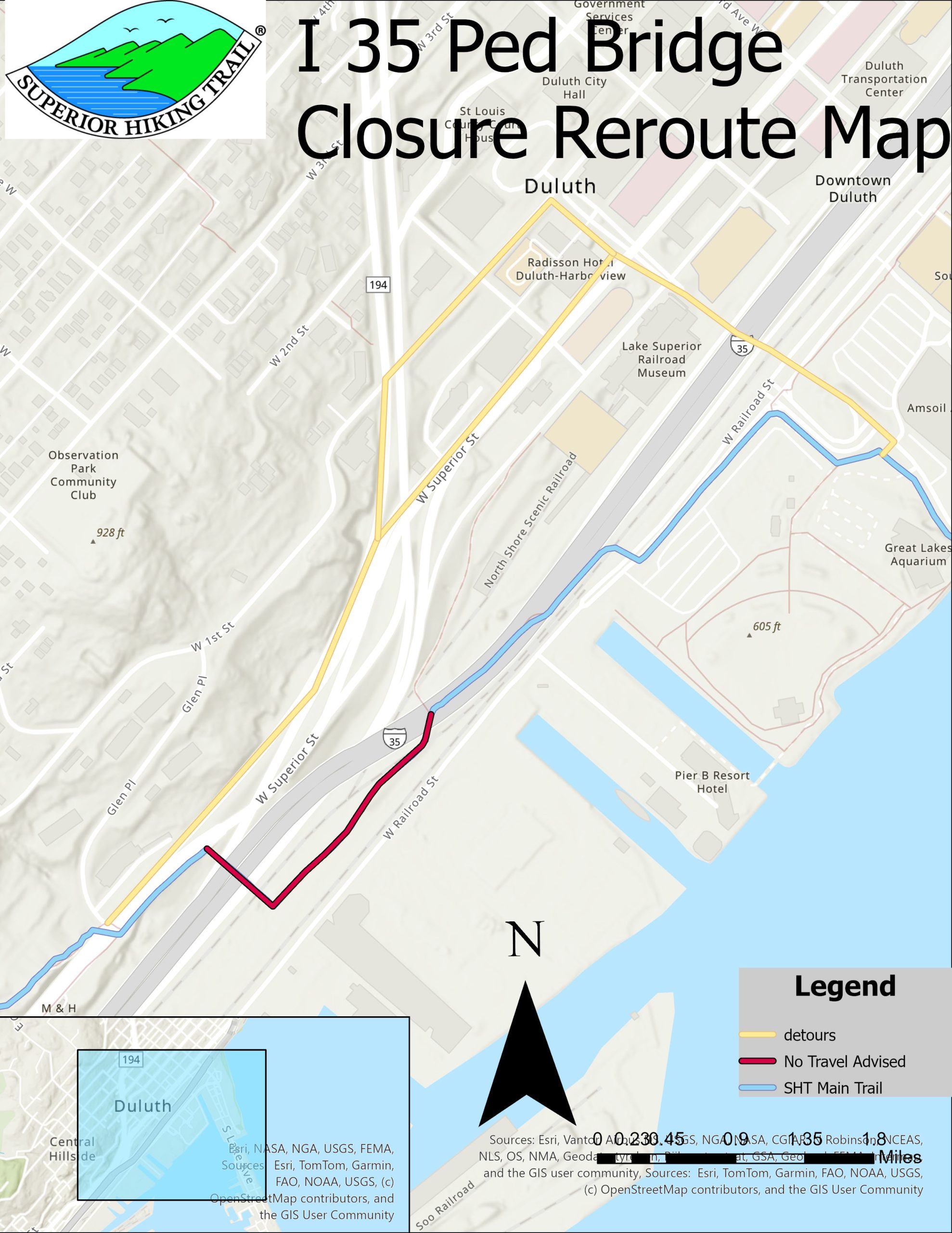
- The I-35 Pedestrian bridge will close to pedestrian traffic at 7 a.m. on Friday, June 12 and will remain fully closed until project competition in October. Multiple reroutes will be in place as the project progresses over the summer. Multiple construction projects are in the area, so multiple reroutes have been mapped. Please use caution while crossing and keep an eye out for detour signage. Additional information on the bridge project can be found here. Reroute: Northbound hikers should follow the reroute signage along Superior Street (and up to First street if closed) to 5th Avenue West, turn Right and use the 5th Avenue Bridge to cross the interstate (sidewalk only on north side) and rejoin the Trail near the Duluth Aquarium. Southbound hikers use inverse directions. A map of the reroute can be found here.
- The SHTA and the City of Duluth are aware that there are multiple encampments of people experiencing homelessness in this vicinity. You may experience garbage on and near the Trail, including broken glass among other unsanitary debris. Sturdy footwear is recommended for those who traverse this section.
Rose Garden to Hartley Park
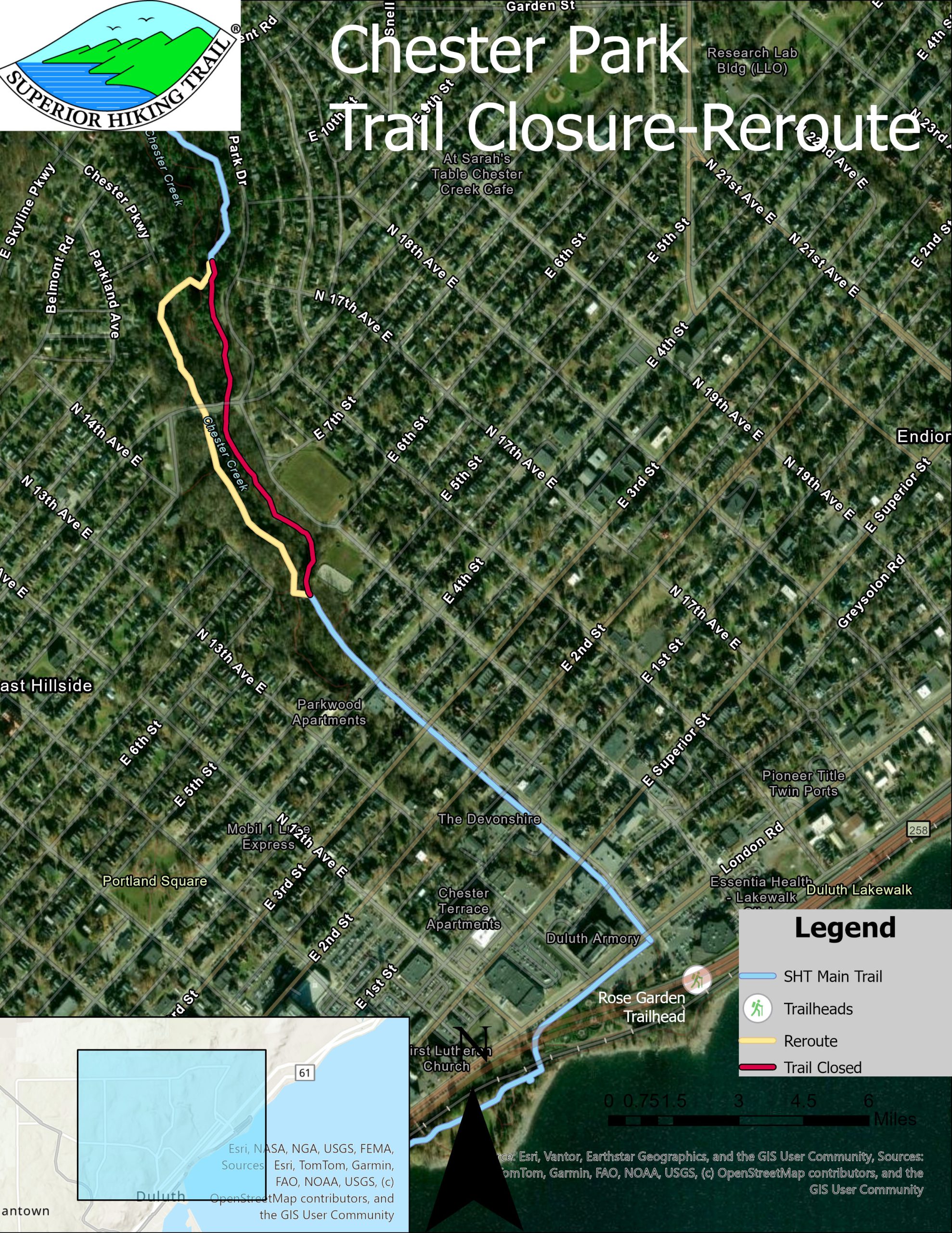
- A construction project in Chester Park near the 8th/9th Street bridge will close and reroute the trail through the park until the project is complete, likely this fall. Northbound users should cross to the trail on the west side of Chester Creek at the first pedestrian bridge they see in the park. Users will go under the 8th/9th Street bridge, and then utilize the next pedestrian bridge to cross the creek and rejoin the Trail. Southbound users should use the inverse directions. A map of the closure and reroute can be found here.
Martin Road Trailhead
- Martin Road Trailhead closes temporarily following the spring thaw to protect the parking area from rutting damage in muddy conditions. This lot is managed by the MN DNR which opens the lot by Memorial Day weekend. It is open for the season.
Martin Road Trailhead to Lake County Road 301 (Fors RD) Trailhead – Map Series B
Martin Road Trailhead
- Martin Road Trailhead closes temporarily following the spring thaw to protect the parking area from rutting damage in muddy conditions. This lot is managed by the MN DNR which opens the lot by Memorial Day weekend. It is open for the season.
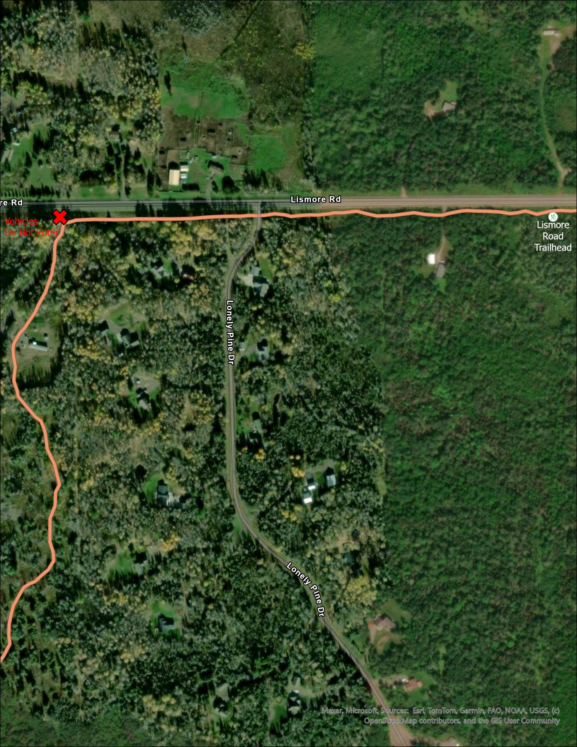
Lismore Road Trailhead is open!
- The new location is located on the southern side of Lismore Road about a quarter mile from the intersection of Jean Duluth Road and Lismore Road. PLEASE DO NOT access the old location, this is a private drive and vehicles are not allowed. Please see the map for more information.
- We have heard reports of interacting and even feeding of private livestock and pets in this area. Please refrain from interacting with livestock, as you would with wildlife and stay on the trail.
Rossini Road Trailhead to Lake County Demonstration Forest Trailhead
- The McCarthy Creek bridge is out. Users should utilize caution and will be required to make a wet crossing at this location.
Lake County Demonstration Forest Trailhead to Reeves Road Trailhead
- Logging activity will be conducted north of this closure beginning the week of August 6th. The trail will remain open to users, and signs will be posted identifying where the activity is taking place. We ask users to use additional caution when passing through this section.
Gun Club Road to Lake County Road 301/Fors Road
- The trail is now open! The distance now between Reeves Road and Fors Road is 5.3 miles and the distance between Gun Club Road and Fors Road is 3.3 miles.
Lake County Road 301 (Fors RD) To Minnesota Highway 1 Trailhead – Map Series C
Lake County Road 301/Fors Road to Castle Danger
- The Encampment River crossing is a shallow ford. Under normal circumstances, it’s an easy crossing with many large rocks. It is only a problem during spring melt or if there has been a large rain event within 48 hours. Here is a roadwalk detour map you can use, but we strongly suggest hiking to the river to assess it before concluding that a roadwalk is necessary.
- There are several other shallow fords in this section. This includes Crow Creek near West Castle Danger Road. Like the Encampment River, this creek is rarely high.
West Castle Danger Road to Gooseberry Falls State Park
- The Gooseberry River has washed out part of the trail away between the West Gooseberry and East Gooseberry Campsites. Please use use caution and be aware you will have to bushwack around the area of the washout.
- A small wooden structure has failed near Middle Gooseberry Campsite. Please avoid stepping onto the structure.
The “Gooseberry Gap” Reroute
- The Gooseberry Gap Reroute is complete! Here is a map that show the new route!
- The Spur Trail from Gooseberry State Park to the main SHT has small areas of slumping along the river, use caution when near the river bank.
- There has been logging activity happening in the area. While the path remains well marked, users should use caution and expect possible logging activity while passing through.
Split Rock to Beaver Bay
- The Chapin Creek bridge has been damaged, please use caution.
- The eastern side of the Split Rock River Loop has been renewed and is open as of June 16, 2025.
- The western side of the Split Rock River Loop has been renewed and is open as of July 10, 2026!
- There is not a bridge over the Split Rock River. Many trail users have crossed the river at the former bridge site during low water. We urge caution if you decide to cross the river. The river may be impassable during high water events. An alternate route exists on spur trails to cross a bridge near Hwy 61 if the water level is high: Northbound, at junction with spur trail turn right (south-east) toward the Split Rock River Wayside. From the wayside, take paved trail to Hwy 61 underpass and turn left. After 0.2 miles, spur trail to main SHT is on left across Hwy 61. Follow spur trail 0.4 miles to junction with main SHT. Southbound: Follow spur trail 0.2 miles to junction with paved bike trail across highway 61, turn right and follow trail to Hwy 61 underpass, and follow to wayside, from the wayside, follow spur trail 0.4 miles to meet with SHT Main Trail.
Cove Point Loop Spur
- Parking at the Cove Point Spur may be limited or not available due to occupancy between May and October. The front desk of Cove Point will be able to help with updates and drop boxes. The front desk of Cove Point Lodge can be reached at 218-226-3221.
Penn Blvd to Minnesota HWY 1
- Bear Lake Campsite Rehabilitation-Open-A campsite rehabilitation project has been completed for the Bear Lake Campsite!
- The Bean and Bear Lakes Loop reopened Friday, September 6, 2024. The Trail Renewal Project on 2.2 miles of the northern portion of the loop has been completed.
- The West Branch Palisade Creek bridge is out, expect to get wet/muddy. Use caution in high water.
Minnesota Highway 1 Trailhead to Temperance River Wayside Trailhead – Map Series D
Lake County Road 6 Trailhead to Lake Road 7 Trailhead
- The bridge over the East Branch Baptism River near the Finland Community Center should be crossed by only one person at a time.
Lake County Road 7 to Sonju Lake Road Trailhead
- The bridge over the East Branch Baptism River is out. Detour is to follow the spur trail to the Sonju Lake Road Trailhead, head west on Sonju Lake Road for about 0.2 miles and turn south on a snowmobile trail to reconnect with the SHT (reserve directions for heading northbound). The total reroute distance is about .4 miles. To see or download a map of the reroute, click here.
Cramer Road to Temperance River State Park
- There is an erosion trench forming at the entrance of the Skou Road Trailhead. Small/low clearance vehicles should use caution when entering the trailhead.
Temperance River Wayside Trailhead to Pincushion Mountain Trailhead – Map Series E
Leveaux Mountain to Lutsen
- The bridge over the Onion River has a weight limit of two people.
- The Onion River Bridge is out for replacement from July 8 to October 4, 2026 conditions dependent. Trail users should proceed with caution and anticipate a wet crossing of the Onion River until the new bridge is complete. Map location can be found here.
Indian Camp Creek
- The bridge over the Indian Camp Creek sustained damage from spring flooding in 2022 and was removed. This narrow creek is easily forded during normal low water conditions but please use caution, especially after rain events.
Cascade River Loop
- The east side of the loop is being worked on by a contractor to make improvements to the Trail. The trail is open but be aware to walk areas where the contractor is working.
- The new blazed reroute and campsite are now open on the west side of the loop! The new mileage between the Cook County Road 45 Trailhead and the spur junction of the trail to the Cascade River Wayside Trailhead is now 3.5 miles instead of 3 miles making a half mile reroute. The ‘Boreal’ campsite that replaces the Big White Pine Campsite is currently 0.4 of a mile south of the Cut Log Campsite. The campsite is finished and open for users. A map of the reroute can be found here.
Pincushion Mountain Trailhead to Northern Terminus – Map Series F
Pincushion Mountain Trailhead to Lindskog Trailhead
- A bridge about .4 mile west of the Lindskog Trailhead has been closed. This is between the Devil Track River Bridge to Lindskog Road Trailhead. Access to the trail up to the bridge is still available but thru traffic is not recommended due to the difficult river crossing without the bridge. The detour for thru traffic is south on Lindskog Road to MN 61, west to 5th Street in Grand Marais, north on the Gunflint Trail till the North Shore State Trail, to the SHT east of the Pincushion Mountain Trailhead. Total distance of the detour is 5.4 miles. A map of the detour can be viewed here.
Lindskog Trailhead to Kadunce River Wayside
- The Cliff Creek bridge is compromised and closed until rehabilitation can happen. Please cross the creek with an abundance of caution.
- Use caution while crossing the Durfee Creek Bridge
Judge C.R. Magney State Park
- A 200’ section of the SHT north of Devil’s Kettle in Judge C.R. Magney State Park is washed out. Please follow the temporary reroute for approximately 250’ around the washed out area and utilize caution.
Camp 20 Road Trailhead
- The last 0.4 of a mile of the road to the trailhead is now signed as a minimum maintenance road. Please be aware and travel at your own risk while accessing this trailhead.
Arrowhead Trail to Otter Lake Road Trailhead
- Carlson Creek Bridge is out on the SHT to the east of Arrowhead Trail Trailhead. This creek can be crossed during normal water levels without this bridge. Please use caution during any shallow water crossing.
- The bridge over Andy Creek has been damaged in a recent storm. Please use caution while crossing the bridge or while crossing the shallow cobble streambed.
- The pond at South Carlson Pond Camp is gone. The beaver pond that was there was drained most likely by spring flood damage to the existing beaver dam. Since the pond was drained there is not a water source at South Carlson Pond Camp. However there is reported to be a good water source a quarter mile north on the SHT at a Carlson Creek crossing.
General Trail Corridor Information
Please respect all Trail and bridge closures set by land managers, State Parks, or the SHTA
You can help us maintain access to the Trail and honor our agreements with private landowners by staying off closed sections. When there is a closure, we will post signs at all nearby trailheads.
A Rugged, Remote Natural Path
The Superior Hiking Trail traverses many different ecosystems, varies in its proximity to population centers, and experiences different levels of use along the length of the corridor. This means a trail users will experience a wide variety of conditions along its 300-mile route. Due to weather events, animal activity, and many other factors, conditions along the Trail can change quickly. You may encounter difficult or challenging conditions not listed on this page like trees blocking the Trail.
We work hard to coordinate annual maintenance to keep the Trail in great shape for us all to enjoy. We value and need your help with maintaining the Superior Hiking Trail. Please report any trail issues you experience on the SHT by using our Trail Incident form. The Superior Hiking Trail Association along with our mighty volunteers works diligently every year to address all trail issues as soon as possible. Interested in joining the fun? Check out our ongoing volunteer opportunities here.
Shallow Water Crossings
The SHT features many unbridged water crossings that most of the year are easily crossed and very shallow. Shallow water crossings may become impassable during periods of significant rainfall or the spring melt (waterfall season). Caution should be used when fording creeks and rivers during high-water events.
During high-water events, the force of the water can undercut creek and river banks on which the Trail and bridge abutments are built and the structure could be compromised but not visible to the eye. If you come to washed out or flooded Trail and bridges, please use caution and report the issue to the SHTA.
Wildlife Advisories
The Superior Hiking Trail is a trail that ventures into remote areas that many wild animals call home. Do not under any circumstances feed or approach any wild animal. It is highly unlikely that an animal poses a threat to you, however if an animal approaches you, that animal could be sick and should be avoided or scared away. For this and many other reasons, please keep your dog leashed on every section of the SHT and always protect your food when camping on the Trail from all animals. Wasp nests have been reported near the Trail, please be aware of this as well.