Know Before You Go
The Superior Hiking Trail is a tour of the unique features of Lake Superior’s North Shore. To enjoy the trail to the fullest, review the information and tips below.
Quick Links
General Trail Information | Navigating the Trail | Trailheads and Campsites | Crossing Public Lands | Leave No Trace | Trail Safety
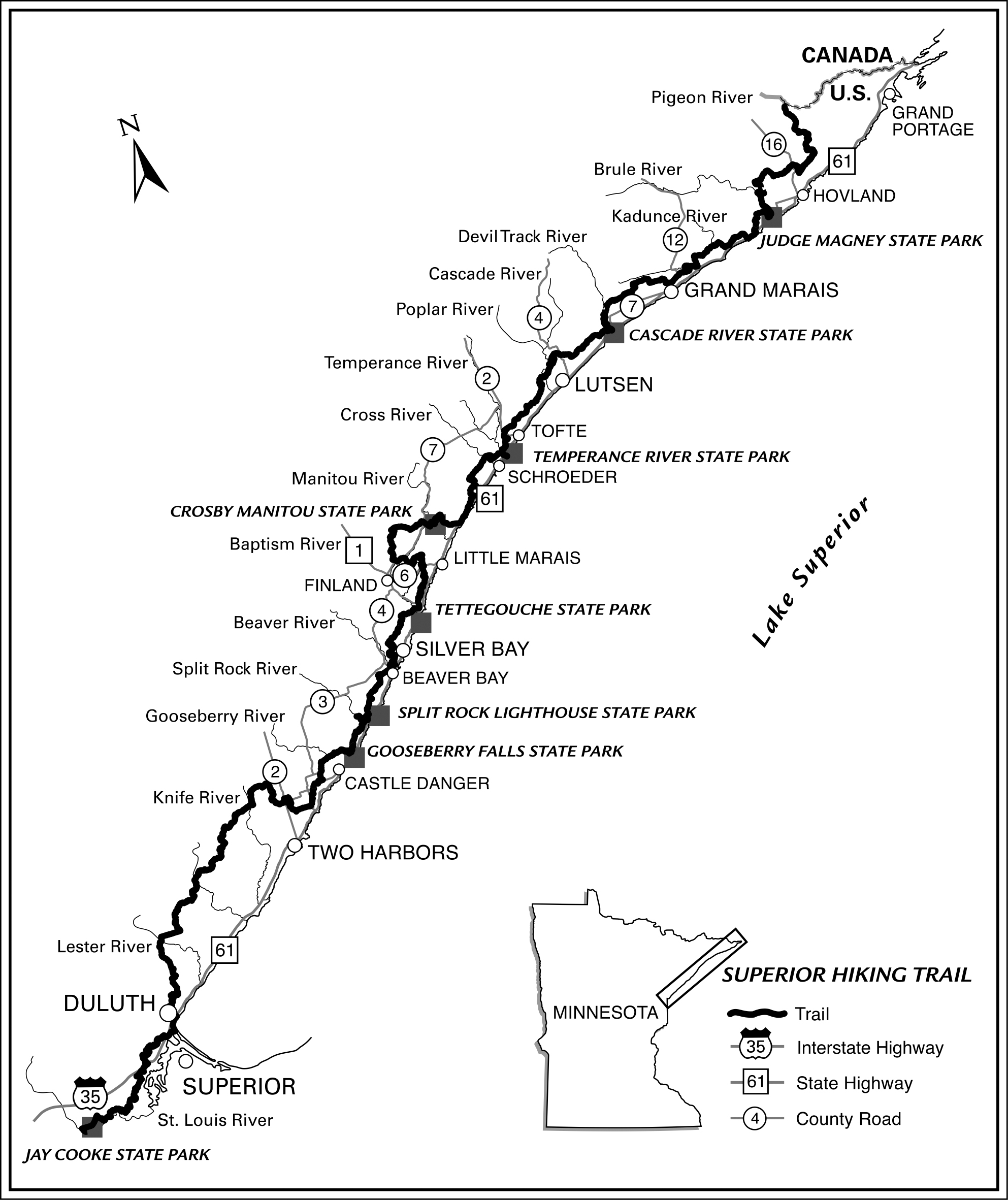
The trail is characterized by ascents to rock outcroppings and cliffs where sweeping vistas of Lake Superior, the Sawtooth Mountains and inland woodlands can be enjoyed. The trail also features stunning descents along rivers, streams, lakes and ponds where thousands of years of rushing water has cut into layers of ancient volcanic rock. In total, the SHT is over 300 miles of main trail and 16 miles of spur trail.
- Optimal for day hikes and trail runs, the southernmost segment of the trail from the Minnesota border through the city of Duluth is 43 miles (41 main trail miles and 2 miles of spur trails). There are no SHTA backcountry campsites within this segment, but thru-hikers and backpackers may choose to use fee-for-use campsites or other lodging arrangements.
- Providing magnificent day hiking, trail running and backpacking camping opportunities, the North Shore segment from the northern Duluth city limits to the northern end of the trail is 269 miles (255 miles of main trail and 14 miles of spur trails).
Elevation Changes
Instead of long climbs and descents found in the mountains, the SHT is constantly ascending and descending. At its lowest point, the Trail is 602 feet above sea level and at its highest point, the Trail is 1829 feet above sea level and more than 100 feet above Lake Superior. Find all elevation profiles in the Superior Hiking Trail Databook.
Allowed Travelers
There are no motorized vehicles, mountain bikes or horses allowed on the Trail except in limited corridors where the Trail is shared with multi-use trail groups. The Trail is not suitable for cross-country skiing, although snowshoe travel is possible and encouraged during the winter months.
Navigating the Trail
The entire Trail is marked with either paint blazes or SHT logo signs, similar the the one seen here:
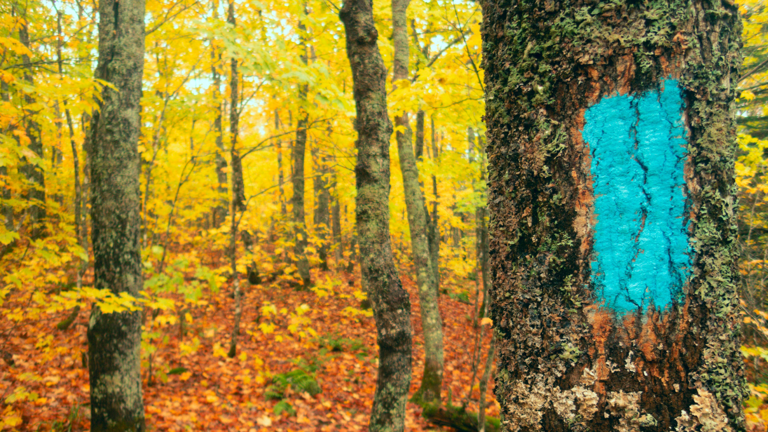
- Spur trails and overlook trails are marked with white blazes.
- Turns in the Trail are marked with two blazes, one slightly higher than the other. The top blaze indicates the direction the trail turns.
- SHT logo markers are posted along the trail, primarily at intersections with roads, other trails, or more populated areas like the route that travels through the city of Duluth.
- The distance between the section gridlines on all SHTA maps is one mile.
Trailheads and Campsites
Trailheads
The distance between trailheads – most from 3 to 11 miles apart with a parking lot at each end – makes the trail easily divisible into day hikes or backpacking trips. Shuttle services are also available along the trail.
Southern sections are accessed from Interstate Highway 35 and Duluth city streets, while Northern sections are accessed directly from Minnesota Highway 61, spur trails or intersecting roads. All trailheads are marked with brown signs showcasing the Superior Hiking Trail logo.
Campsites
There are 94 campsites along Superior Hiking Trail maintained by the SHTA and our volunteers. SHT campsites:
- are located away from roads and must be hiked into,
- require no permits or reservations but must be shared,
- have space for generally 2-5 tents,
- have one centrally-located fire ring,
- typically have benches,
- have an open-air backcountry latrine,
- and most, but not all, are located near a natural water source which will require treatment prior to consuming.
To learn more about SHT campsites, purchase the 9th Edition Superior Hiking Trail Guidebook in our Trail Store.
Basic Camping Rules
- Plan ahead and stay at designated campsites only to avoid disturbing habitat or accidentally trespassing on private lands. No camping is allowed at any SHT trailhead.
- All campsites and campsite infrastructure must be shared. Please be courteous and make room for fellow campers.
- Break up large groups to avoid overcrowding. Most SHT campsites are designed to be enjoyed by 9 or fewer people at a time. If you plan on travelling with a group of 8 or more people, please review the Large Groups on the SHT page.
- Hammock hangers must stay at the designated campsites. Note: Some hammock hangers have reported difficulties at Heron Pond, Bear Lake, Section 13, Jonvick Creek, Sundling Creek, and Andy Creek Campsites. If planning to hang a hammock, please plan alternate sites.
- Use the backcountry latrine at campsites whenever possible. If a latrine is full, do not use it and please report it to us using the trail incident report form. If no latrine is available, bury human waste as deep as possible and at least 200 feet from water.
- Build fires only at designated fire rings – and never burn garbage. The fire rings at each site have been installed to minimize fire danger. Carry a camp stove and consider not having a fire to minimize your impact. If you choose to have a fire, it is your responsibility to guarantee that the fire is 100% out. It is also your responsibility to abide by any burn bans which may be in effect.
- Respect wildlife and fellow campsite users by keeping your pets on-leash. Dogs are welcome on the SHT, but must be kept on a leash for the protection of wild animals, plants, and the comfort level of fellow hikers—regardless of how well-trained your dog is.
- Respect wildlife by securing your food. Always use a bear canister or bear-bag your food.
- Leave the campsite in better condition than you found it.
Camping reservations and permits
There are no permits, fees, or reservations needed to stay at an SHT campsite. The Trail also passes several state park campsites. These require a reservation and fee through the state parks. Do not stay at a state park campsite unless you have reserved it and paid for it.
To learn about how sharing campsites on the Trail can be really fun, check out the blog Share Good Times (and Campsites) on the SHT by Anna Swarts.
Crossing Public Lands
The Trail crosses national forest and state parks, state, county and municipal property and private property. Landowners – individuals, corporations and governmental units – have granted permissions for the trail to cross their land. Please respect private landowner rights by staying on the trail, following blue blazes, camping only at designated sites and keeping your dog on a leash.
Leave No Trace
One of the most important ways you can help protect and preserve the Superior Hiking Trail experience is to practice the seven principles of Leave No Trace. Below we’ve suggested how you can put each into practice specifically on the SHT. Together we can preserve the Trail and the environment surrounding it.
Below is an overview of all principles.
Plan ahead and prepare
The most important step to avoid impacting the landscape is to be prepared for what you’ll encounter on the Trail. Know your camping arrangements ahead of time, choose a section appropriate with your skill level, carry a map, research appropriate gear and check Trail Conditions before heading out.
Travel and camp on durable surfaces
Staying on the Trail and camping ONLY at designated campsites limits the impact of visitors to our fragile ecosystem and ensures that our private and public landowners remain supporters of our Trail.
Dispose of waste properly
Pack it in, pack it out! There are no SHTA-sponsored garbage cans or garbage services, so bring a designated baggie for your trash and carry it out with you. This includes food scraps (even orange peels and seed shells) and toilet paper if a latrine is not available.
Leave what you find
Don’t take anything from the trail (and don’t leave anything!). Don’t cut names into trees. Be mindful of invasive species, using a boot brush or other device to clean your gear before and after traveling on the Trail or between sections.
Respect wildlife
Keep your dog on a leash. It’s the rule of the Trail and the law of the land in many sections. If you make the effort to bag your dog waste, be sure to pack it out with you too. Campers: make sure you secure your food. This means carrying a bear canister or diligently bear-bagging your food. Wild animals are not pets. Please leave them in their wild state.
Be considerate of other visitors
Remember that people enjoy the SHT in many ways: some hike, some run, some meander at a half a mile per hour. Our Trail is a shared, beloved resource. Treat everyone with respect. SHT campsites must be shared with other users. Be courteous and welcoming. Avoid using Bluetooth or other loud speakers on the Trail and campsites.
Learn more about ‘Leave No Trace’ here.
Trail Safety
Before setting out, be prepared for the type of terrain and weather conditions you may encounter, referring to the SHTA Trail Conditions pages for any recent updates. Also, remember to:
- Wear sturdy footwear and pack an extra clothing layer or rain gear if conditions warrant.
- Carry adequate water (river and lake water along the Trail must be treated before it is consumed).
- Use insect and tick repellant.
- Know your route and observe and follow trail signs and blazes.
- Carry a map and compass. You can purchase maps from our Trail Store.
- Let someone know your plans and always know where you are in a trail to speed up assistance in a potential emergency.
- In an emergency requiring immediate medical or law-enforcement response, call 911. There are Search and Rescue crews in each county the Trail crosses.
 100vw, 1985px" />)