Sections South to North
 100vw, 2560px" />)
Temperance River State Park to Britton Peak
Length
4.8
Miles
Campsites
![]() 0
0
Directions
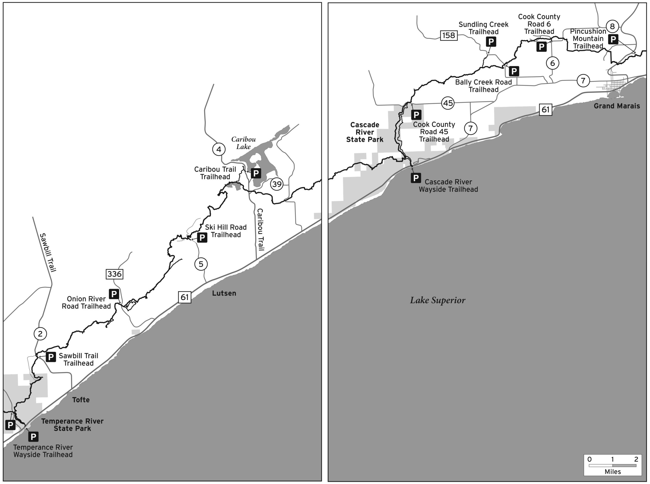
Temperance River State Park Trailhead: At Hwy. 61 milepost 80.3 on left side of highway. No overnight parking. Overnight parking allowed at other parking area in park with state park sticker; check-in with state park staff.
Description
- Mileage includes 0.2 mile of access spur trail. Thru-hiker mileage for this section is 4.6 miles
- Climbs along thundering Temperance River in gorge
- Incredible views from top of Carlton Peak
- Spur trail to Ted Tofte Overlook

Britton Peak to Oberg Mountain
Length
5.7
Miles
Campsites
![]() 4
4
Directions
Britton Peak Trailhead: At Hwy. 61 milepost 82.8, turn left on Cook Co. Rd. 2 (Sawbill Trail) and go 2.7 miles to parking lot on right. Overnight parking okay.
Description
- Rolling hike through maple and birch forests
- 0.2 mile spur to Britton Peak and amazing views, particularly during fall color season
- 1.3 mile Leveaux Mountain Loop
- Considerable mud on this section except in dry times
Oberg Mountain to Lutsen Mountains Recreation Area
Length
7
Miles
Campsites
![]() 3
3
Directions
Oberg Mountain Trailhead: At Hwy. 61 milepost 87.5, turn left on Forest Rd. 336 (Onion River Rd.) and go 2.2 miles to parking lot on left side of road. Overnight parking okay, outhouse at trailhead.
Lutsen Mountains Recreation Area Trailhead: At Hwy. 61 milepost 90.1, turn left on Cook Co. Rd. 5 (Ski Hill Rd.) and go 2.9 miles to recreation area. Park in general parking areas or continue 0.3 miles up road past gondola and restaurant to small trailhead parking lot on left. Overnight parking okay in both areas. Bathroom, restaurants, drinking water at trailhead.
Description
- Mileage includes 0.4 mile of access spur trail. Thru-hiker mileage for this section is 6.6 miles
- Spectacular overlooks on 1.8 mile Oberg Mountains loop
- Tough climbs and descents of Moose and Mystery Mountains
- 0.8 mile spur goes to Lutsen Mountains gondola. Spur trail closed Nov 1 – June 1 for ski season.
Lutsen Mountains Recreation Area to Caribou Trail
Length
6.4
Miles
Campsites
![]() 4
4
Directions
Lutsen Mountains Recreation Area Trailhead: At Hwy. 61 milepost 90.1, turn left on Cook Co. Rd. 5 (Ski Hill Rd.) and go 2.9 miles to recreation area. Park in general parking areas or continue 0.3 miles up road past gondola and restaurant to small trailhead parking lot on left. Overnight parking okay in both areas. Bathroom, restaurant, drinking water at trailhead area.
Description
- Mileage includes 1.2 mile of access spur trails. Thru-hiker mileage for this section is 5.2 miles
- Scenic section with stretches paralleling Poplar River and beautiful Lake Agnes
- Steep descents and ascents with multiple vistas of Poplar River Valley
- Spur trail to White Sky Rock with incredible view of Caribou Lake
Caribou Trail to Cascade River State Park
Length
11.0
Miles
Campsites
![]() 3
3
Directions
Caribou Trail Trailhead: At Hwy. 61 milepost 92.0, turn left on Cook Co. Rd. 4 (Caribou Trail) and go 4.1 miles to Co. Rd. 94. Turn right and take immediate left to trailhead parking lot. Overnight parking okay, outhouse at trailhead.
Description
- Mileage includes 1.3 miles of access spur trails. Thru-hiker mileage for this section is 9.7 miles
- Features White Sky Rock overlook spur and Lake Agnes
- Follows maple ridgelines with views of Lake Superior and the Sawtooth range
- Crosses several scenic creeks and near thundery waterfalls on Cascade River
- Panoramic views from Lookout Mountain
Cascade River State Park to Bally Creek Road
Length
10.0
Miles
Campsites
![]() 4
4
Directions
Cascade River Wayside Trailhead: At Hwy. 61 milepost 99.9 on the left side of the highway. The main SHT is on the west side of the river. The spur trail on the east side of the river has a crossing of Trout Creek with no bridge, which may not be passable in the spring or after rain events. There is a bridge upstream 0.2 miles from the wayside parking lot to cross from one side of the river to the other. No overnight parking at the wayside. Overnight parking is available by Cascade River State Park campground with a state park sticker; check in with state park staff.
Alternate Parking Option #1: Co. Rd. 45 (Pike Lake Rd.) on the north end of Cascade River Loop. At Hwy. 61 milepost 101.5, turn left on Co. Rd. 7 and go 2.0 miles to the junction with Cook Co. Rd. 44. Continue straight on Co. Rd. 44 for 0.5 miles. Turn left and go on Co. Rd. 45 for 2.6 miles to the parking lot on the right. Overnight parking is okay.
Alternate Parking Option #2: Co. Rd. 158 (Bally Creek Rd.) at the Sundling Creek spur trail. At Hwy. 61 milepost 101.7, turn left (north) on Co. Rd. 7 and go 4.3 miles. Turn left on Co. Rd. 48 and go 0.3 miles to the “T” intersection. Turn left on Forest Rd. 158 (Bally Creek Rd.) and go 1.9 miles (passing the first SHT parking lot on Bally Creek Rd.) to the large grassy parking lot on the left. Overnight parking is okay.
Description
- Mileage includes 0.5 miles of access spur trail. Thru-hiker mileage for this section is 9.5 miles
- The trail heads upstream paralleling Cascade River
- Views of Eagle Mountain (the highest point in the state of Minnesota)
- 8.3 mile Cascade River Loop goes up one side of the river and crosses a bridge over the river on Co.Rd. 45 (Pike Lake Rd.) and goes back down the other side
Bally Creek Road to Grand Marais
Length
8.3
Miles
Campsites
![]() 2
2
Directions
Bally Creek Road Trailhead: Co. Rd. 158 (Bally Creek Rd.) At Hwy. 61 milepost 101.7, turn left (north) on Co. Rd. 7 and go 4.3 miles. Turn left on Co. Rd. 48 and go 0.3 miles to the “T” intersection. Turn left on Forest Rd. 158 (Bally Creek Rd.) and go 1.0 mile to the trailhead parking lot on the left. Overnight parking is okay.
Alternate Parking Option: Cook Co. Rd. 6/115F parking lot. At Hwy. 61 milepost 101.7 turn left (north) on Cook Co. Rd. 7 and go 6.0 miles. Turn left on Cook Co. Rd. 6 and go 1.5 miles to the pull-through parking lot at the intersection with 115F. Overnight parking is okay.
Grand Marais Trailhead: At Hwy. 61 milepost 110.0, turn left on Cook Co. Rd. 12 (Gunflint Trail), and go 2.0 miles. Turn right on Cook Co. Rd. 53 (Pincushion Drive) and go 0.25 miles to the parking lot. Turn from Gunflint Trail has a sign marked “Scenic Overlook.” Overnight parking okay, outhouse at trailhead.
Description
- Features scenic Sundling Creek and a large beaver pond
- Passes through large red pine forest
- Joins the North Shore State Trail (multi-use trail mainly used as a snowmobile trail) for 2.5 miles before a steep descent with views of Lake Superior