
Maps tell stories: a profile of collaboration
November 30th, 2023
If you’ve taken a hike or a run on the Superior Hiking Trail during the past 30 years, chances are very good you used a map produced by Matt Kania to plan or navigate.
Kania’s dual talents in cartography and fine art have made him a perfect and long-time collaborator with the Superior Hiking Trail Association. “I got involved with the Superior Hiking Trail in the earliest days by helping to create the first guidebook for the Trail,” Kania said.
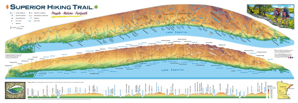
This year, Kania helped us produce a new version of our popular profile map of the Superior Hiking Trail, originally created in 1995. “It was really exciting to work on the contemporary version, and incorporate the new data. The trail is much more extensive than it was on the previous version. It’s exciting to see the elevation change along the entire corridor, especially now that the trail goes down to the border of Wisconsin,” Kania said.
Our new SHT Profile Map is now available in our Trail Store.

Kania has teamed up with the SHTA many times over the years, producing the SHT pocket maps, designing the map insets for the 7th to 9th edition guidebooks, and creating the My SHT Map that helps End-2-Ender hikers and runners track their progress completing the Trail in sections.
Last year, Kania also created three beautiful art prints that capture the best features of the SHT, “Rivers and Creeks,” “Peaks and Knobs,” and “Lakes and Ponds.” We created apparel featuring Kania’s drawings from the prints. All of these products sold in our Trail Store have helped fund the creation, management, and maintenance of the SHT.
The Duluth-based cartographer and artist is fascinated by the spatial aspects of the world, from the macro perspective of a map maker to the micro perspective of a plein air landscape artist.
“That’s one of the reasons I’ve been interested in maps all these years,” Kania said. “I’ve been a cartographer for 35 years, but I’m also an artist. I love telling stories through maps. I call it cartographic communication, being able to tell a story to a specific audience in map form.”
The juxtaposition of Kania’s large scale and micro scale study of our Northshore landscape reveals to him just how fortunate we are to be in this particular location, he said. “We are so lucky to have the Superior Hiking Trail.”
The new elevation map details many points of interest along the Trail from Ely’s Peak near the southern terminus to the 270-Degree Overlook at the northern terminus, as well as the elevation change along the trail corridor. The map shows in intricate detail what Kania loves about the Superior Hiking Trail, how rigorous and rugged the landscape is.
“This map will be great to have on the wall for people to talk about their adventures on the Trail in an intelligent way. It can show their friends and families where they’ve been,” he said.
Kania, owner of Map Hero, Inc. has been a cartographer for 35 years, and has worked with large local and national clients from the Minnesota Historical Society to the National Park Service. Exhibits featuring his maps are currently on display at the Cape Cod National Seashore and Denali National Park and Preserve. He is also a well-known painter and printmaker who especially enjoys the practice of plein air painting (French for painting outside on location), which he has practiced on the Superior Hiking Trail. Two examples of paintings completed on the SHT include “Cascade River Gorge,” left, and “Pincushion Spring,” right.
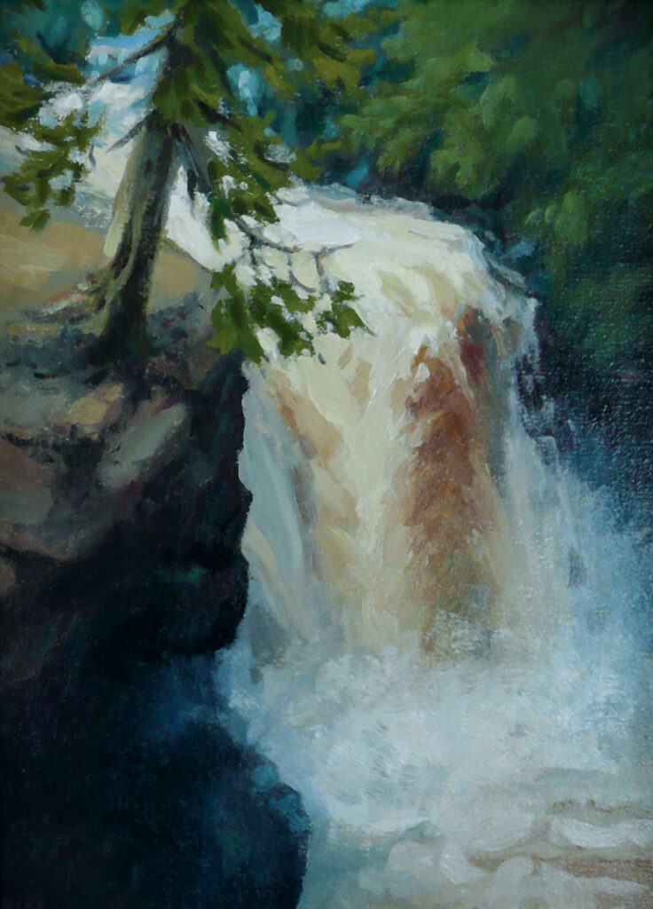
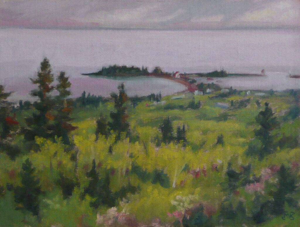
“One of the reasons I started plein air painting was to engage more deeply with my surroundings. It’s a wonderful experience to be day hiking or thru-hiking on the Superior Hiking Trail, but I can engage much further if I’m on location for hours painting a beautiful white pine, rushing river, or amazing vista,” Kania said.
If you’re interested in seeing other examples of Kania’s cartography, go to www.maphero.com. His fine art and plein air paintings can be seen online at www.mattkania.com and Instagram, @mattkania. He will also have work featured in two exhibits in 2024 in the Twin Cities and Duluth. At the Bell Museum in St. Paul from January through May, Kania will be part of a group show featuring plein air paintings of Minnesota biomes. He will have two paintings on exhibit from northern Minnesota. Kania will also be featured in a solo exhibition at the Great Lakes Aquarium in Duluth June through August with plein air works from a three-year project on Isle Royale National Park documenting the ravaging effects of a 2021 wildfire, and the forest’s regeneration.
The Superior Hiking Trail Association is very grateful to have collaborators like Matt Kania who share their talents with our Trail Community. We hope you enjoy our new SHT Profile Map as much as we do!
By Annie Nelson, SHTA Development and Communications Director