Sections South to North
Trail Alerts 
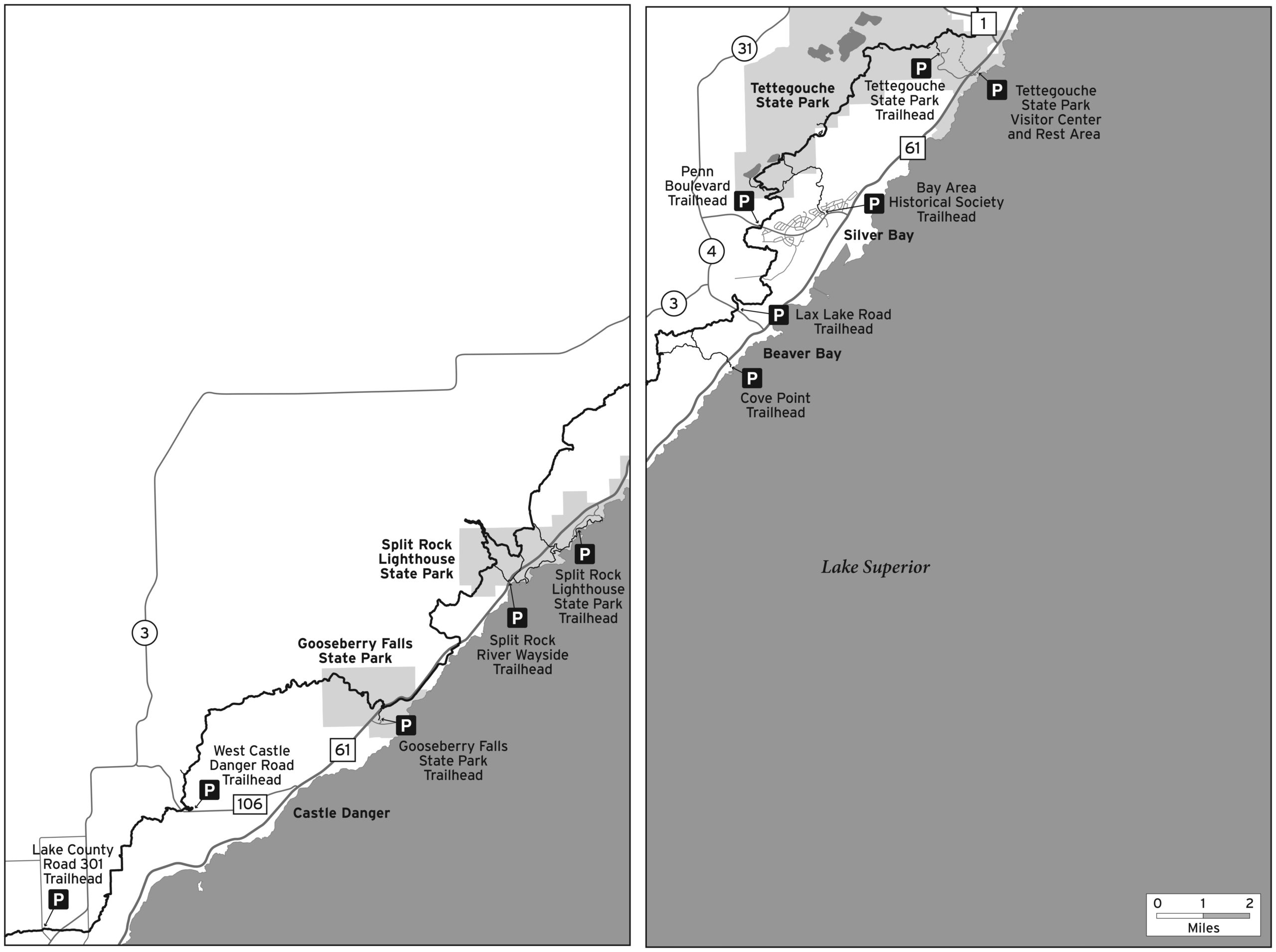
Lake County Road 301 to Castle Danger
- Jan 06, 2023 This section is closed for a week for private forest management.
Split Rock River Loop at Split Rock River Wayside
- There is no bridge over the Split Rock River on the SHT. Many trail users have crossed the river at the former bridge site -- we urge caution if you decide to cross the river. Visit the Trail Conditions page to find details on an alternate route.
Silver Bay to Tettegouche State Park and Highway 1
- High Falls bridge is permanently closed. Please use reroute south towards visitors center.
 100vw, 2560px" />)
Lake County Road 301 to Castle Danger
Length
6.3
Miles
Campsites
![]() 0
0
Directions
County Road 301 Trailhead: At Hwy. 61 milepost 28.5, turn left on Lake Co. Rd. 3 and go 2.0 miles. Turn left on Lake Co. Rd. 301 (Fors Rd.) and go 0.3 miles to parking lot on left. Overnight parking okay.
Description
- Rolling valleys up to pine-studded ridgelines
- No bridge on Encampment River in middle of section. Stepping stone crossing in low water, not crossable after rain events and spring run-off. Roadwalk around section posted at Trailhead parking lot.
- Mostly private land in this section, so stay on trail at all times. Absolutely no camping in this section!
Trail Alerts
- Jan 06, 2023 This section is closed for a week for private forest management.

Castle Danger to Gooseberry Falls State Park
Length
8.73
Miles
Campsites
![]() 5
5
Directions
Castle Danger Trailhead: At Hwy. 61 milepost 36.6, turn left on Lake Co. Rd. 106/Silver Creek Township Rd. 617 (West Castle Danger Rd.) and go 2.4 miles to trailhead parking lot on right. Overnight parking okay.
Description
- Thru-hiker mileage for this section is 8.73 miles – New Route Map
- Starts with short but steep climb to ridgeline with views of forests and Lake Superior
- Mike’s Rock with nice views
- 4 miles along meandering, scenic Gooseberry River
- Spur trail to Gooseberry Falls State Park Parking Lot is 3.34 miles
- Long spur trail down to towering waterfalls, State Park Visitor Center, and Lake Superior
Gooseberry Falls State Park to Split Rock River Wayside
Length
7.5
Miles
Campsites
![]() 1
1
Directions
Gooseberry Falls State Park Visitor Center: At Hwy. 61 milepost 38.9, turn right and follow road to day use parking. Overnight parking okay with a state park sticker; check-in with state park staff.
Description
- Spur trail from Gooseberry parking lot is 3.34 miles – New Route Map
- Thru-hiker mileage for this section is 7.5 miles
- Stunning 1 mile Breadloaf Ridge overlooking Lake Superior
- Descend through lovely aspen and birch forests toward Split Rock River
- Spur trail from Split Rock River Wayside is .8 miles
Split Rock River Loop at Split Rock River Wayside
Length
5.0
Miles
Campsites
![]() 4
4
Directions
Split Rock River Wayside: On Hwy. 61 milepost 43.5 with parking lot on left. No overnight parking.
Description
- Mileage includes 1.2 milse of access spur trail. Thru-hiker mileage for this section is 3.8 miles
- Highlights are cascading waterfalls and towering Split Rocks
- Trail goes 2.5 miles up one side of the river, crosses at former bridge site, and descends other side for 2.5 miles, leaving river and climbing to high point with views of Lake Superior.
- At Hwy. 61, SHT crosses highway and goes on paved Gitchi-Gami State Trail to box culvert under Hwy. 61 with access to beautiful sand beach at mouth of river.
Trail Alerts
- There is no bridge over the Split Rock River on the SHT. Many trail users have crossed the river at the former bridge site -- we urge caution if you decide to cross the river. Visit the Trail Conditions page to find details on an alternate route.
Split Rock River Wayside to Beaver Bay
Length
10
Miles
Campsites
![]() 3
3
Directions
Split Rock River Wayside: On Hwy. 61 milepost 43.5 with parking lot on left. No overnight parking. .8 mile spur trail.
Alternate parking for this section: Split Rock Lighthouse State Park. At Hwy. 61 milepost 49.0, turn right on entrance road. Pass contact station, turn right and follow road to Trail Center parking lot. Follow state park trails 2.3 miles to SHT spur trail going to main SHT. Overnight parking okay with state park sticker; check-in with state park staff.
Description
- Mileage includes 0.8 mile of access spur trail. Thru-hiker mileage for this section is 10 miles
- Challenging section with steep ascents and descents and dramatic views both of Lake Superior and inland
- Trail climbs down a fault line ridge onto the valley floor and climbs out again by large beaver pond to more ridgeline views
- 6.0 mile Cove Point Loop in middle of section starts and ends at Cove Point Lodge.
Beaver Bay to Silver Bay
Length
4.4
Miles
Campsites
![]() 2
2
Directions
Beaver Bay Trailhead: At Hwy. 61 milepost 51.1, turn left on Lake Co. Rd. 4 (Lax Lake Rd.) and go 0.8 miles to parking lot on right. Overnight parking okay.
Penn Blvd. Trailhead in Silver Bay: At Hwy 61 milepost 54.3, turn left at stoplight on Outer Drive and go 1.5 miles to Penn Blvd. Continue straight 0.5 miles on Penn Blvd to parking lot on right.
Description
- SHT shares snowmobile trail for 0.5 miles, then turns right to follow Beaver River
- Trail climbs to majestic pine forest with rocky outcrops
- After descending, trail climbs again to more views of inland forests and Lake Superior
Silver Bay to Tettegouche State Park and Highway 1
Length
11.1
Miles
Campsites
![]() 5
5
Directions
Hike Option: Bean and Bear Lakes Loop (also called the Twin Lakes Trail), 6.8 miles. From the Penn Blvd. Trailhead parking lot, take the main SHT 3.6 miles to see lovely Bean and Bear Lakes to the junction with the loop trail, which is 0.2 miles past the Bear Lake Campsite spur. Then take the loop trail back through the woods to the main trail and back to the parking lot.
There is an alternate start to this loop trail hike at the Bay Area Historical Society/Silver Bay Visitor Center. This 2.3-mile spur starts on Silver Bay ATV trails for 0.7 miles and is then on a nice trail through the woods to the loop. The total mileage for this option is 7.6 miles. Directions to Visitor Center: At Hwy. 61 milepost 54.3, turn left at the stoplight on Outer Drive, and go 0.5 miles to the Visitor Center on the right.
Silver Bay (Penn Boulevard) Trailhead: At Hwy. 61 milepost 54.3, turn left at the stoplight on Outer Drive, and go 1.5 miles to Penn Blvd. Continue straight 0.5 miles on Penn Blvd. to the parking lot on the right. Overnight parking is okay.
Alternate Parking Option #1: Tettegouche State Park Wayside. At Hwy. 61 milepost 58.5 on the right. No state park sticker is required. Day use only. To access the SHT, take the state park spur trail to High Falls of the Baptism River.
Alternate Parking Option #2: State Park parking lot inside state park. At Hwy. 61 milepost 58.5 on the right. Take the road to the picnic area and large parking lot. Overnight parking is okay with a state park sticker; check in with state park staff.
Description
- Very challenging and scenic section with views of Lake Superior and inland forests
- Views of Bean and Bear Lakes from the trail on the ridge
- Incredible views from Round Mountain, Mount Trudee, and Raven Rock
- A steep descent down the Drainpipe, a series of giant rock steps
- Crosses on the bridge over High Falls of the Baptism River, the highest falls entirely in Minnesota
Trail Alerts
- High Falls bridge is permanently closed. Please use reroute south towards visitors center.